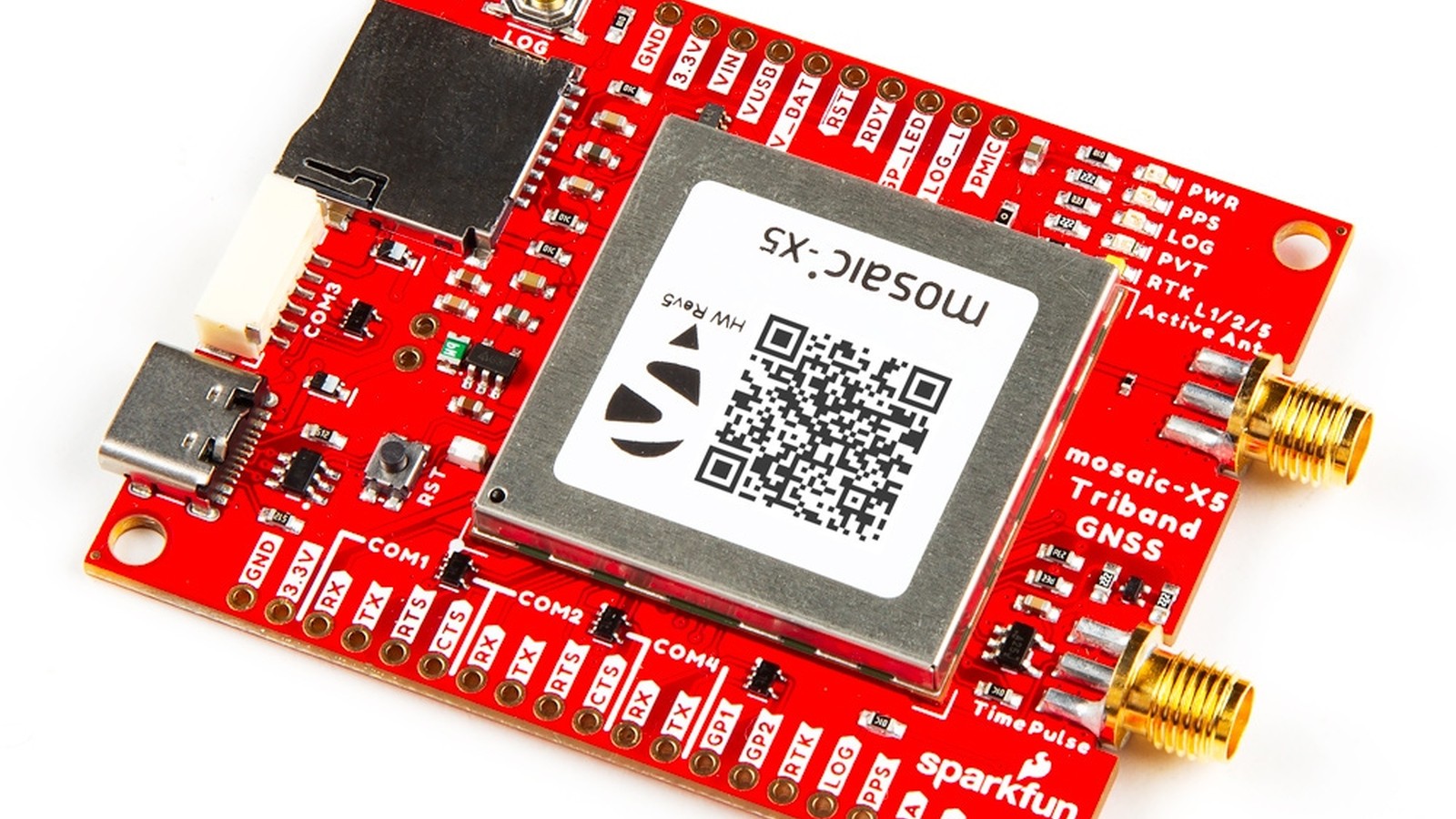
SparkFun's Triband GNSS RTK Breakout built around Septentrio's mosaic-X5 brought professional positioning features to a developer-friendly board in October 2023. The receiver tracks signals across the L1, L2, and L5 bands and supports multiple satellite constellations, while real-time kinematic corrections can reduce positioning error to the centimeter range.
This is not simply a more sensitive GPS module. The mosaic-X5 targets surveying, mapping, robotics, machine control, and research applications that need repeatable coordinates, high update rates, and better resilience around interference and reflected signals.
Triband reception provides more information
GNSS is the broad term for satellite-navigation systems. GPS is the United States system, while Galileo, GLONASS, BeiDou, NavIC, QZSS, and satellite-based augmentation systems provide other signals and regional services. SparkFun lists support for this wider group through the mosaic-X5.
Each satellite transmits ranging information. A receiver estimates its distance from several satellites and solves for position and clock error. Tracking more constellations improves the chance of seeing a useful geometry when buildings, trees, terrain, or equipment block parts of the sky.
The L1, L2, and L5 labels refer to different radio-frequency bands. Multi-band measurements help the receiver estimate and correct ionospheric delay, one of the errors introduced as signals travel through the atmosphere. They also provide more observations for rejecting poor measurements.
A triband receiver still needs a suitable antenna. The antenna must cover the required frequencies, receive power if it is active, and be mounted with a useful view of the sky. A high-end receiver cannot recover signals that a poor installation blocks.
RTK turns corrections into precise coordinates
An ordinary standalone GNSS fix commonly has meter-scale error. Real-time kinematic positioning, or RTK, compares measurements from a moving receiver with corrections from a reference station whose location is known accurately.
The reference can be a local base receiver or a correction service reached over radio or the internet. Because the base and rover experience many of the same satellite and atmospheric errors, the rover can use the corrections to resolve carrier-phase measurements and produce a much more precise result.
SparkFun lists RTK performance for the mosaic-X5 at 0.6 centimeters plus 0.5 parts per million horizontally and one centimeter plus one part per million vertically. The parts-per-million term means error grows with the distance between the rover and correction source. Those figures describe receiver capability under appropriate conditions, not a promise for every antenna placement or environment.
RTK solutions move through states. A float solution has not fully resolved the carrier ambiguities. A fixed solution has and is normally the centimeter-class result users want. Applications should record the solution type, satellite count, correction age, and estimated accuracy rather than saving coordinates alone.
High-rate output serves moving systems
The mosaic-X5 provides 448 tracking channels and position updates up to 100Hz, according to SparkFun's specifications. A 100Hz output produces a new solution every 10 milliseconds. That can benefit fast robots, drones, vehicle testing, and motion studies where a one-hertz location stream misses important movement.
High update rate does not automatically mean high accuracy. The antenna, correction link, dynamics settings, output configuration, and environment all influence results. It also increases serial traffic and storage. Log only the messages the application needs and confirm that the host can process them without falling behind.
SparkFun lists latency below 10 milliseconds and a cold start under 45 seconds. Latency is critical in control systems because an accurate position that arrives late describes where the machine was. A full system should measure the delay from satellite observation through receiver output, communications, software, and actuator response.
Time information can be as important as position. A pulse-per-second output provides a precise timing edge that can synchronize cameras, sensors, computers, or distributed instruments. The board exposes PPS and other signals for integration, but voltage levels and timing configuration should be checked before connection.
AIM+ addresses interference and spoofing
Modern GNSS receivers operate with very weak signals arriving from space. Nearby transmitters, poorly shielded electronics, harmonics from digital systems, and intentional jammers can overwhelm them. Reflections from buildings and vehicles create multipath, where delayed copies distort measurements.
Septentrio's AIM+ technology is designed to identify and mitigate interference. The receiver also includes anti-spoofing features intended to detect misleading signals. These capabilities are valuable for dependable systems, but they do not eliminate the need for good RF design.
Place the antenna away from noisy processors, displays, switching regulators, and high-current wiring. Use appropriate coaxial cable and connectors, maintain a ground plane where the antenna requires one, and inspect spectrum or receiver diagnostics when performance changes.
Spoofing resilience also requires system-level checks. A robot can compare GNSS motion with wheel encoders and an inertial sensor. A fixed station can flag a sudden jump. Critical equipment should enter a safe state when navigation quality becomes questionable rather than trusting one data source blindly.
SparkFun exposes practical development interfaces
The breakout includes USB-C, microSD storage, an SMA antenna connection (a small screw-on coaxial connector standard used for RF cabling), status indicators, buttons, and access to receiver signals. USB simplifies configuration and high-rate data transfer to a computer. The card slot supports standalone logging for surveys and field tests.
Septentrio's web interface gives users a visual way to inspect tracking, configure outputs, and monitor receiver status. A friendly interface helps during bring-up, but configurations should be exported and documented. Two receivers that look identical can behave differently because one setting changed months earlier.
The board can output standard and vendor-specific messages for host software. NMEA sentences, plain-text position messages defined by the National Marine Electronics Association, are widely understood and convenient for basic position data. Binary formats carry richer measurements more efficiently. Choose the minimum set required by the application, including quality indicators and correction status.
For embedded integration, verify baud rates, logic levels, boot behavior, and connector pinouts before designing a carrier. High-rate raw observations can exceed a link configured for simple one-hertz NMEA output.
A disciplined first RTK test
Begin outdoors with the antenna on a stable mount and a wide sky view. Configure a modest update rate and inspect standalone tracking before introducing corrections. Confirm constellations, signal levels, antenna power, and time.
Next, connect a known correction source and watch the receiver progress toward an RTK fixed solution. Record how long fixing takes and how it behaves after corrections stop. Repeat near trees and structures to understand the difference between an open test site and the intended deployment.
Place the antenna over a marked point and log for an extended period. Plot east, north, and height error rather than relying on the receiver's estimated accuracy alone. Move the antenna through a measured course if the final application is dynamic.
Finally, test recovery. Briefly block the antenna, interrupt the correction stream, restart the host, and cycle power. A positioning system is defined as much by how it reports degraded operation as by its best fixed result.
Where the mosaic-X5 board fits
The board is more receiver than a basic hobby GPS project requires. A simple clock, geotag, or rough outdoor tracker can use less expensive hardware. Its value appears when errors of a meter are unacceptable, measurements must arrive quickly, or the RF environment demands better diagnostics.
Survey tools, precision agriculture, mobile mapping, autonomous machines, geophysical instruments, and synchronized sensor rigs are natural candidates. The breakout format lets developers evaluate those applications without first building a dense RF board around the module.
SparkFun's release made Septentrio's triband receiver accessible in the company's familiar development style. The board can shorten the path to a centimeter-class prototype, while its specifications also make clear that precision positioning remains a complete-system problem involving antennas, corrections, timing, software, and careful validation.
I'd begin outdoors with a good antenna and a wide view of the sky, and log long enough to see how the receiver behaves before building anything around it.
Sources and image credits
- SparkFun Triband GNSS RTK Breakout - mosaic-X5, SparkFun Electronics.
- Introducing the Triband GNSS RTK, SparkFun news.
- mosaic-X5 hookup guide, SparkFun documentation.
- Official product image from SparkFun Electronics.
- Square and vertical crops are edited from the same source image.